
Hiking Cerro Otto is a challenging half day adventure in Bariloche, Argentina. This short but difficult trail has rewarding views of the city of Bariloche, Lake Nahuie Huapi and surrounding mountains. It is conveniently located within the city centre and can easily be reached via public transportation.
This guide will outline helpful information required to successfully hike Cerro Otto including route options and trailhead details by car and public transit.
Cerro Otto Trail Information
- Distance: 9km
- Elevation Gain: 629m
- Trail Type: Loop
- Difficulty: Moderate/Hard
- Washroom Facilities: None
Clockwise vs Counterclockwise
This hike can be completed in either direction; although difficulty could vary depending on which way you choose. Clockwise begins through a field of flowers and woods with many different paths. The ascent is through a covered forest and the terrain is steep but soft.
Counterclockwise ascends though neighborhoods before tackling the side of a mountain, with lots of scrambling involved. The loose sand and rocks make for a steep and slow climb.
Recommended route: Counterclockwise. While the initial climb is slow and steep, it’s a safer climbing up the loose terrain than it is climbing down. Stick with the wooded area on the return.
How to Get to the Trailhead of Cerro Otto
By Car
If arriving by car, travel from the center of Bariloche to Av. de los Pioneros. There is free parking at the Telerifico Cerro Otto. Across the road and beside the police station is the trailhead.
By Local Bus
There are two options you can choose from to reach the Cerro Otto trailhead by public bus: Line 50 or Line 20. I opted for Line 20 as this bus ran more frequently than Line 50. This route will add an additional 2km each to your hike.
- Line 20
- Route: Bus Terminal – Downtown (Centro) – Llao Llao.
- Bus timetable here
- Price: 92 ARS per way paid by SUBE

If taking Line 20, get off at Avenida Bustillo (Km 5) in front of A Orillas del Lago. From the bus stop, follow the signs indicating Cerro Otto, down Sara María Furman. This neighborhood road is quiet, so you shouldn’t expect to see tons of vehicles.

After 1km, the Telerifco Cerro Otto (Cerro Otto Cable Car) will be on your left-hand side. This cable car transports guests to the top of the mountain.
If you want to shorten the hike, you can opt to ascend or descend using the cable car. They are opened Monday to Saturday, from 10am-4:30pm. A single fare for adults is 3000 ARS and 4500 ARS for a return trip. The price for children and seniors is 3500 ARS for a roundtrip.

Across from the road, beside the Police station is a fence and a narrow dirt path. This is where the official trailhead begins. It doesn’t look like much, but I assure you, this is the correct path.

The Cerro Otto Loop Route
The trail will hug the fence line for the next 1km. These narrow paths will lead past 7 neighborhood roads, so be cautious while moving from road to trail. At times, the path can be very narrow, and the overgrown bush can make for a tight squeeze.


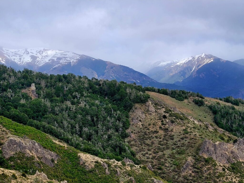
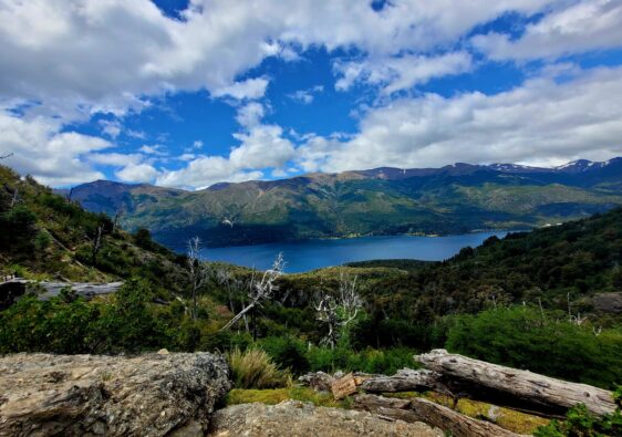
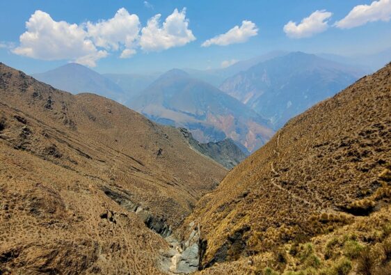
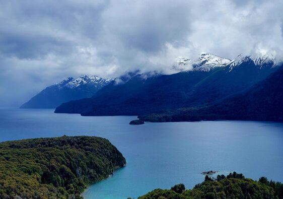
At the 2km mark (3km from the bus stop), you pass by one of the cable lifts towers and water tanks. This is where you will leave behind the neighborhood and venture into more isolated and rocky terrain. Looking back, you will always have beautiful views of Lake Nahuie Huapi.


The goal of the hike is to reach the top of the hill for 365 panoramic views of the city and mountains. To do so, you need to follow the cable car. Since the trail is quite steep for 3km, I would recommend taking breaks at each cable tower.
I encountered strong winds during my hike and found myself breaking more frequently than planned. Take shelter when you can, the sandy terrain is no fun in strong winds.


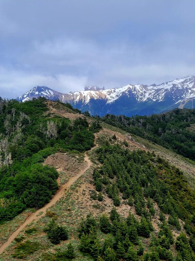
There are a few areas that require some mild scrambling over rocks. The trail does level out for a few minutes after the small climb. At this point, the terrain becomes softer and sandier.


The final climb up to Cerro Otto is a little more challenging. I often found myself off path or just creating one through the rocky and sand. If you are moving up and forward, you are headed in the right direction.
I had trouble with this section, as the sand caused each step to feel slower and sluggish while the strong winds were disorienting and blew sand in my face . As mentioned earlier, I would not advise going down this way, as the path is tricky and incredibly steep.
Once you are finally at the top, you will find yourself on a gravel road. Head right and continue this gravel road until you reach the Rotating Confectionery and art gallery.

Gorgeous views of the mountains will be on your right-hand side as you proceed up. At the time of my visit, the trails leading into the mountains were blocked off, otherwise I would have loved to explore the area.
This hillside is popular in the winter months, where you can zip line, snowshoe, and slide down the slopes and surrounding forests. The facilities were closed at the time of my visit, for maintenance.

To head back down from the mountainside, take the road on the right-hand side through the trees. This path will lead down the mountain and provide breathtaking views once again of the lakes and city centre.
This is the main road leading to Cerro Otto, so once again be wary of vehicles along the way.


The Return Route Back to Bariloche
There are three options to get back to Bariloche from Cerro Otto. The first is to continue to walk along the road, down into the city centre, which takes around 6km to reach the outskirts of town. This path is best left for those with access to a car.
The second option is to take the cable car back down to Terrifico Cerro Otto (if it’s operating).
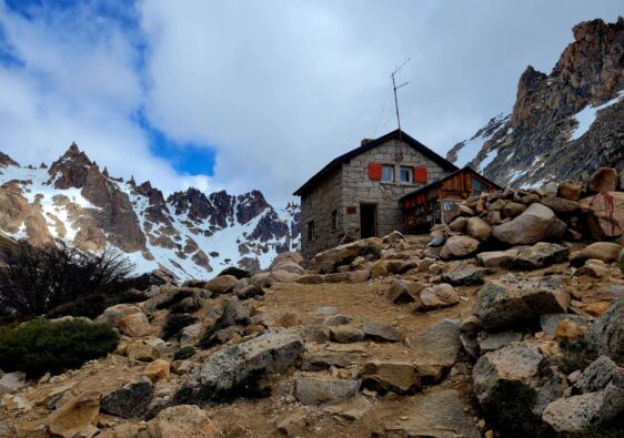
The third and final route is located 1.3km from Cerro Otto. I chose this route, as I wanted to get my steps in and wanted a challenge.
As you walk down the road, you will reach a turn off on the left-hand side for Refugio Berghof. Take the stairs towards the refuge and continue down through the forest.


I found the path going down was more difficult to navigate through. While the terrain was soft and not overly challenging, there were too many paths to choose from. I did use an AllTrails map but still found myself double checking I was going in the right direction.
Trails split off into three, sometimes four options. Although, most of the time, these trails would reconnect, or all end up in the same place. Once again, as long as you are descending down the forest, you should end up in the right area.
I did have to crawl through two fence lines unfortunately. However, it seemed to be a common, as several people commented on this trail having to do the same thing.

On flat ground, and depending on the time of year, you will pass by beautiful golden bushes. This trail will lead abruptly out into a parking lot on Avenida de los Pioneros and across from a supermarket named La Anónima.


Head back along this road to reconnect with your original path towards the Cerro Otto Chair Lift. If you took the bus (Line 20), head back up Sara María Furman. The colourful bus stop will be on the left-hand side once you reconnect with Avenida Bustillo.

Further Exploring in Bariloche
If the elevation of Cerro Otto is a little extreme, there are other options in and around Bariloche.
Villa Tacul Loop is a casual hike located in the Llao Llao National Park. This 15km trail is a gentle hike along the perimeter of the park, with beautiful views of the surrounding lakes and islands.
Refugio Frey is 45 minutes away from the Centre of Bariloche and offers amazing mountain views and alpine lakes.
I love all of your detailed guides. If I ever make it Argentina, I would definitely have a lot of good hikes to choose from with your guides.
Thank you
Wow this is a great guide and super detailed! love it!
Wow, the view from the top of Cerro Otto is glorious! What a great comprehensive post, full of great tips for this hike. I’ve not been to Argentina yet, but views like this is what I’d be looking for.
Would it be cheating if I took the cable cart? It looks so much fun! And the views over the snowy mountains are breathtaking!
Ha! If the cable car was operating at the time of my hike I probably would have done the same!
Thanks for providing such a detailed view of how to do the hike at Cerro Otto. I was tempted by the “short” but worried when you said “challenging”. But I can certainly see why it was worth it for the views. I am sure we would opt for the cable car back down.
Oh gosh I can’t imagine doing a strenuous hike while having sand blown up at me – but the mountain and lake views look absolutely worth it! 🙂
This hike looks so hard but the scenery is just so beautiful! Thanks for sharing this.