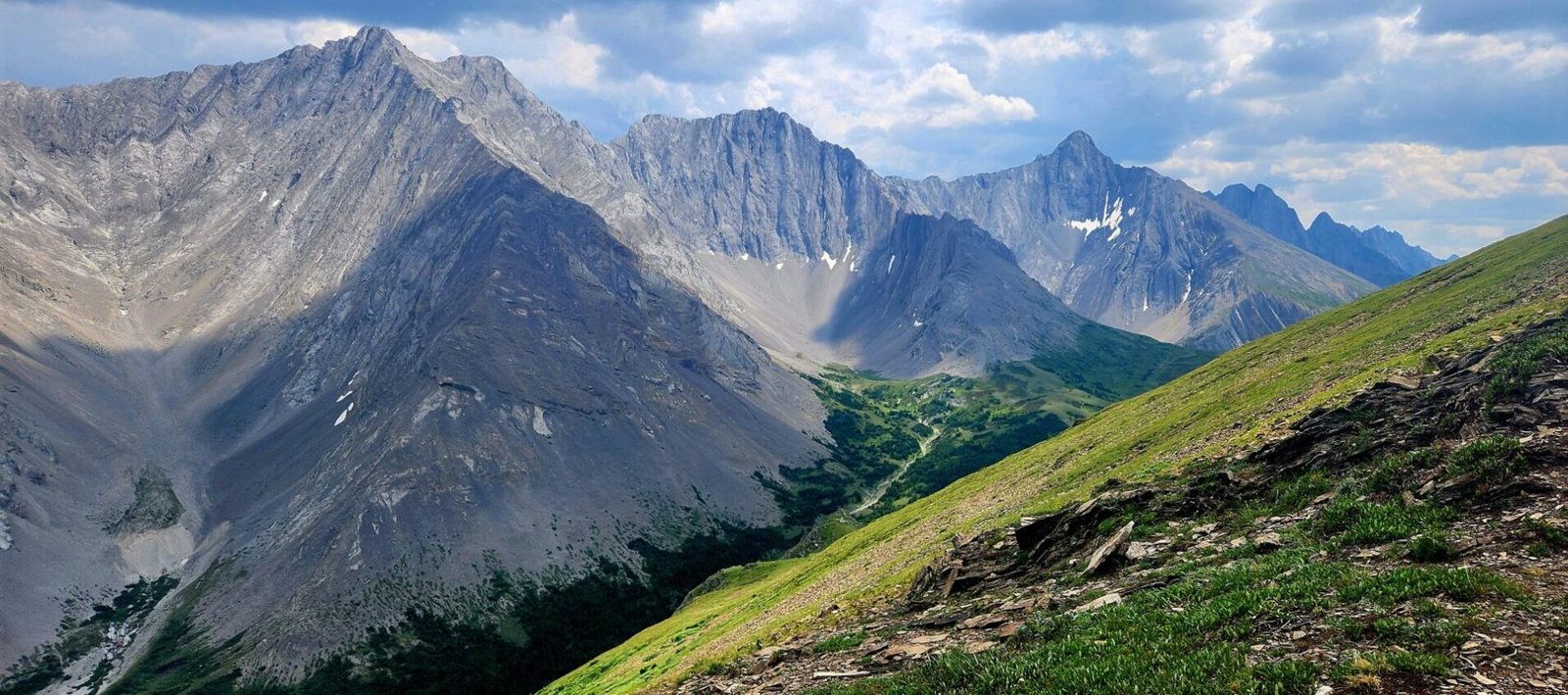
The Opal Ridge South Summit in Kananaskis is a fantastic grind and thrilling hiking experience. Those wishing to tackle this challenging summit will require skill in scrambling and a healthy amount of surefootedness. Conquering the steep ascent will reward hikers with awe inspiring views of the heart of Alberta’s Kananaskis Country, and even a little bit of BC in the distance.
Opal Ridge is an 8km roundtrip hike gaining 1000m in elevation and passes through varying rocky terrain. This hiking overview will act as a guide, providing trailhead information, safety, and route descriptions.
Disclosure: I only recommend products I would use myself and all opinions expressed here are my own. This post may contain affiliate links that at no additional cost to you, I may earn a small commission.
Opal Ridge South Summit Trail Information
- Distance: 8km roundtrip
- Duration: 5-6 hours with breaks
- Elevation Gain: 1000m
- Trail Type: Out & Back
- Difficulty: Hard
- Facilities: None at trailhead or on route. Find washrooms at Galatea Trailhead or at Fortress Junction Service Station
- Required permits: Kananaskis Conservation Pass
Best Time of Year to Hike Opal Ridge
Plan your visit to Opal Ridge during the summer months and early autumn, as winter conditions can make your access more difficult. Snow can linger until late June, so I would recommend hiking during July-September. One thing to note, this is a very steep trail, so avoid hiking while it’s raining or has recently rained. This trail is very exposed to the elements, including sun and wind.
I hiked Opal Ridge in July and encountered no snow, however it started to rain on the descent and made the trail increasingly more difficult.
How to Find the Trailhead for Opal Ridge
The Opal Ridge trailhead is approximately 116km (1 hr 20 mins) southwest of Calgary and 71km (50 mins) southeast of Canmore.
Calgary driving route here
Canmore driving route here
The trailhead for Opal Ridge is located at the Fortress Junction Service Station in Kananaskis Country along Highway 40. This service station is open year-round and provides gas, liquor, groceries, and hiking/camping supplies.
Parking for the trailhead can be found on the left-hand side of the service station. As with a lot of hikes in Kananaskis, there are no official maps or trail information board indicating there is a trail, which I find quite misleading.

difficulty level
The hike to Opal Ridge is not an easy trek. While the ridge to summit portion of this trail is suitable for all ages and fitness levels, the 900m climb to get there is where the difficulty comes in. The trail gains 250 meters in elevation every kilometer, making for a very slow ascent.
The terrain is a mix of loose gravel and scree, adding to the difficulty of the route. There is a lot of scrambling required for this hike, climbing over and above boulders, rock walls and steep slopes.
The 2km mark of the trail is intense as there are several scree paths to choose from. While they all eventually lead to the ridge, choosing the most appropriate path for your skill level is challenging. You may find yourself veering off path several times.
Some may argue the descent back down from the ridgeline is more difficult and I would completely agree. While the climb is tiring, especially in the heat, the way back down is considerably harder. Take your time, invest in a good pair of hiking boots, and use poles or sticks for assistance.
I would recommend this route for those with an intermediate level of hiking experience. In 30 degree weather, I found this hike to be very challenging but very rewarding.
Route Overview
From the car park, walk towards the trail that runs alongside the creek (not the path that says DO NOT ENTER). This path will climb into the tree line, before turning left and proceeding along a flat road with telephone lines. This is one of the few sections of the trail that is flat, so enjoy it while it lasts.


The trail will turn right again and head straight up the mountain. The trail will be essentially vertical up the mountain for the next 3.5km until reaching the ridgeline.


While there are a few areas to scramble through this section, it’s still manageable. The dirt ground is slippery but can be overcome with good traction.

The Endless Climb
Around 1.5km, the terrain will change and have more scree and slabs of rock. This section is fun as it requires climbing, but can pose a challenge for those unfamiliar with scrambling.
There are some markers along this area (orange/red ribbon on trees) but I find they tend to lead you on the harder route.

I can’t imagine being able to climb this area during wet conditions. I visited during a very dry day and had difficulty navigating myself along the scree. This is more of a choose your own adventure area.

I chose the path to the left side of the mountain and regretted it. Stick to the right side, as it’s less extreme. On the way back down keep to the left during this section as there are more large rocks and patches of grass to use for better footing. Again, there are no defined routes along this section, so pick a route that works for you.

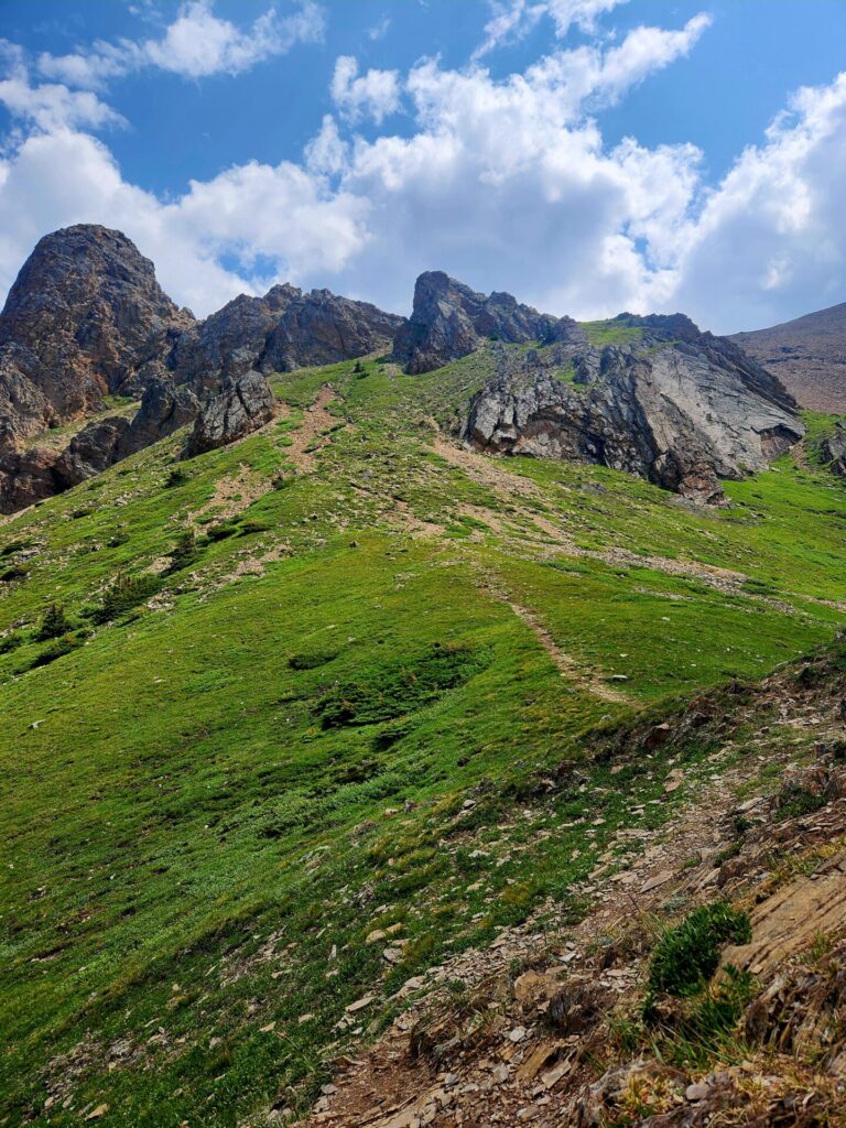
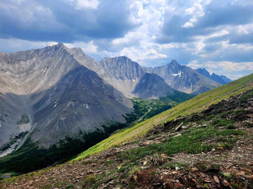
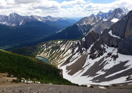
There are several rock walls that will need to be climbed before you reach the final push to the ridgeline. Once past the rock wall, the lush green false summit will be revealed.


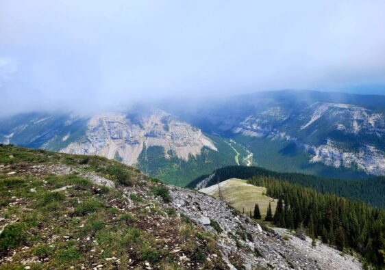
This area is spectacularly beautiful and arguably more of a sight than the actual peak. The path proceeds up to the ridge but breaks apart and becomes less defined as you progress.

This is another time where it’s good to take a minute and decide which is the best way to proceed based on your skill level. Take extra care in this area, especially if others are navigating above you, there is plenty of loose rock that could become dislodged and roll down the hill in your direction.
This section once again lacks a clear path and most people opt to venture towards the grassy areas a foot away from the path, as it can be a safer option on this particular steep section.
While I am an advocate for sticking on route to avoid further destruction to the path and environment, the safety of others and myself will always come first.
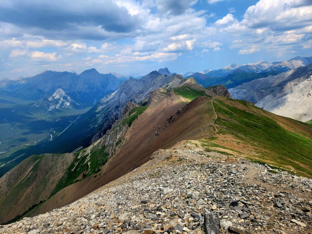
The Ridge Walk
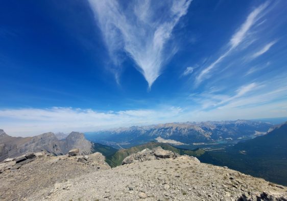
Once you hit the ridge, rest your legs, and take in the beauty around you. The ridge walk is around 1km and showcases the true beauty of the hike. The path is narrow and is very exposed in certain sections.
The ridgeline ends with another steep but manageable and clear climb to the summit. This final push to the top goes much quicker than the previous 900m climb.


There is a small pink box that houses notepads and other little trinkets from hikers who have completed the hike. This is where I would consider the end of the ridge walk.

AllTrails suggests the ridge continues, and while it does, it’s not something that I would recommend, as the route is unmarked and narrow while it traverses over the exposed ridge. To be frank, it’s dangerous and doesn’t provide any new views.
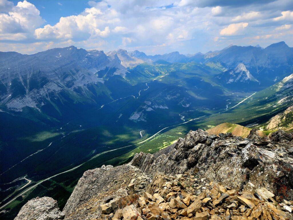
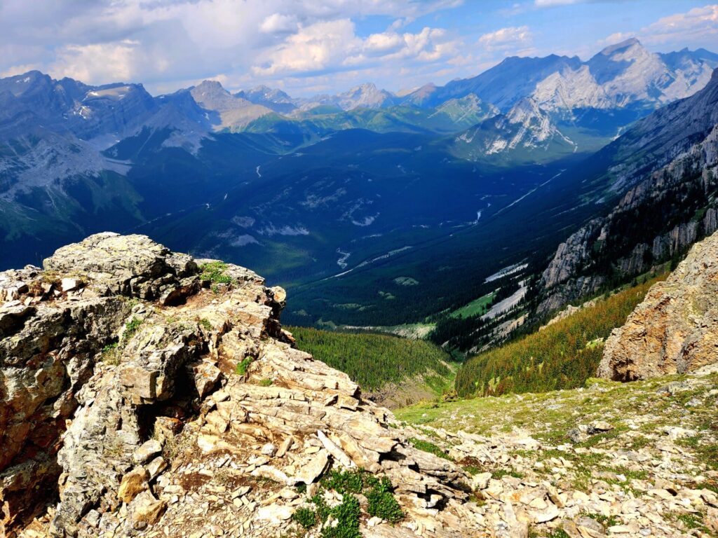
From the summit you will be able to see the highway below, 360-degree views of mountains, including the beautiful summit meadows of Grizzly Peak just a few kilometers to the south.
The journey back to the service station is slow and requires some additional navigation through the poorly marked scree. As someone who suffers from anxiety on descents, I managed to keep it together and not lose my footing while on route.
Verdict: Tough climb but very rewarding!
Further Exploring
If you are looking for another rewarding hike, but less intense, I’d recommend Tent Ridge Horseshoe. While this hike has rugged terrain and requires minor scrambling, the elevation gain isn’t as intense and provides 360 degree views of stunning lakes and mountains.
Accommodations in the Area
If you don’t want to make the drive from Calgary or Canmore, there are a few places you can stay around Kananaskis including a unique glamping option on the way to the trailhead.
Alternatively, you can stay near Dead Man’s Flats, which is a short distance from Canmore.
Sundance By Basecamp: CHECK PRICES AND AVAILABILITY
Banff Gate Mountain Resort: CHECK PRICES AND AVAILABILITY
Copperstone Resort : CHECK PRICES AND AVAILABILITY

The photos are gorgeous! I am sure you have had as much fun as I had looking at those photos. The ridge walk require a lot of courage though. I am not made for these hikes/ treks.
What a trail!! OMG.
I know I would find the 1000m elevation gain tough but the ridge walk along the top looks spectacular! I love the colours and fabulous lighting you had. There was a pink summit box just like that on the top of Mount Lineham – I wonder if there is a hiking group that supplied a bunch of them!?
What an epic adventure! And those views are stunning! I love the pink box of notes. There’s something similar in LA on the Wisdom Tree hike. Always fun to read the notes.
Please stay on the trail and do not walk on the grass when descending. Destruction and erosion from big boots will ruin the area.